Phitsanulok province covers some 10,5815 square kilometres. The riverside provincial capital is 377 kilometres north of Bangkok. Pitsanulok is situated on the geographical and administrative line uniting the central and northern regions. Phitsanulok was the birthplace of King Naresuan the Great of Ayutthaya (reign: 1590-1605), and his brother Prince Ekathosarot. Phitsanulok has long been an important centre for political and strategic reasons. Phitsanulok was a major centre of recruitment when Ayutthaya waged war with Burma (Myanmar), and was the capital of Thailand for 25 years during the 1448-1488 reign of Ayutthaya's King Boromatrailokanat. |
| Major Attractions |
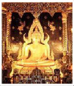
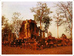
| Wat Phra Si Rattana Mahathat This river side temple is a major city landmark and houses one of Thailand's most beautiful and significant Buddha images, Phra Buddha Chinnarat, which was cast in 1357. The striking mother-of-pearl doors were built in 1756 by Ayutthaya's King Borommakot. The museum in the temple compound houses a collection of Sukhothai art. |
 |
Mae Ping Lake Cruises
Popular cruises originate from the Bhumibol Dam to Chiang Mai's Doi Tao Self-Help Settlement edging the dam reservoir, a total distance of 140 kilometres. Full details may be obtained from the Educational Tour Centre, Tel: (Bangkok) 221- 5183, or the Thongnatee Company Limited, Tel: 457-3428, 467-2557.
Lan Sang National Park
Located on the Tak-Mae Sot Highway (Route 105), 17 kilometres from
Wat Chulamani
The temple's corncob-shaped tower, or prang, is another city landmark. The temple is regarded as being Phitsanulok's oldest historical site and contains some exceptionally elaborate plaster designs.
King Naresuan the Great Shrine The shrine is located in the compound of the Phitsanulok Phitthayakhom School, and depicts the seated king ceremoniously declaring Ayutthaya's independence from Burma (Myanmar). The shrine was constructed on the site of the Chandra Palace where King Naresuan was born in 1555. |
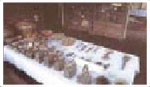
| Sergeant-Major Dr Thawi-Pim Buranakhet's Folklore Museum |
| Opposite the Buranathai Buddha Casting Factory on Wisutkasat Road, this attractive museum houses a charming collection of local folk arts and crafts, including basketry, pottery and ancient kitchen utensils. |
 |
| Nan River Houseboats
People living on houseboats on the Nan River adhere to a tradit i o n a l lifestyle that is fast disappearing in Thailand. |
| O ut-of-City Attractions |
| (Phitsanulok-Lomsak Road/ Highway No. 12) Sakunothayan Botanical Garden |
This park is located at Km 33 via a 500 metre access road. The picturesque Wang Nok Aen Waterfall, some 10 metres in height, cascades among rocks to create a soothing sight. |
| Kaeng Song Waterfall. |
| This cascade is located beside the road at Km. 45. |
| Poi Waterfall |
A sign at Km 61 reads Suan Pa Khao Krayang, and introduces a 2-kilometre access road to Poi Waterfall, which is distinguished by a copious flow and profuse rocky outcroppings. Many species of flowering trees grace the area. |
| Kaeng Sopha Waterfall |
A road at Km 70 branches off some 2 kilometres through forest beyond the Thung Salaeng Luang National Park office. The waterfall is Phitsanulok's largest. |
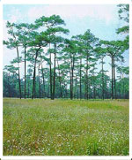
| Thung Salaeng Luang National Park |
The forested park covers more than 300,000 acres spreading across Phitsanulok and Phetchabun provinces. The park office is located at Km 80 on the picturesque Phitsanulok-Lomsak Highway. |
| Phuhinrongkla National Park |
This park of arresting scenic beauty spreads across parts of Phitsanulok, Phetchabun and Loei provinces. Major attractions include Lan Hin Taek natural rock formations covered with orchids, ferns, lichen and wild flowers. The park is reached by turning left at the Km 68 marker onto the Phitsanulok-Nakhon Thai road, travelling for 28 kilometres to Ban Nong Krathao where a right turn begins the final 28-kilometre stage to the park office. |
| Chat Trakan National Park |
This park, covering more than 60,000 acres, lies 135 kilometres from Phitsanulok provincial capital along the Phitsanulok- Lomsak Highway until Km 68, thence on Highway 2013 and then to Amphoe Chat Takran. A seven-tiered waterfall within the park is the source of the Kwae Noi River which unites with the Nan River in the provincial capital. |
| Major Events |
| The Phra Buddha Chinnarat Fair |
The six-day fair occurs on the sixth day of the waxing moon of the third lunar month, usually late February, at Wat Phra Si Rattana Mahathat, and features homagepaying, folk entertainment and cultural performances. |
| Boat Races |
Long boat races are customarily staged during the first weekend of October on the Nan River fronting Wat Phra Si Rattana Mahathat. |
| Sukhothai |
In 1238, Sukhothai ('Dawn of Happiness') became the first truly independent Thai kingdom.Historical artifacts have demonstrated that Thai culture, most particularly the Thai alphabet and Thai language, originated in Sukhothai. |
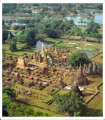
Sukhothai province covers some 6,596 square kilometres. The provincial capital is some 427 kilometres north of Bangkok. The province's major attraction is the ancient city of Sukhothai, which largely forms the Sukhothai Historical Park, which is a UNESCOdesignated World Heritage Site. |
| City Attractions |
| Sukhothai Historical Park |
Ruined temples, palaces and irrigation systems help evoke much of the former capital's splendour. The ancient city walls measure 2,000 metres by 1,600 metres. |
| The Royal Palace & Wat Mahathat |
The moated 160,000 square metre royal palace area contains Wat Mahathat, Sukhothai's largest and most important temple. Massive stone Buddha images preside over a complex of columns, lotusbud towers and picturesque pagodas reflected in lotus ponds. |
| Wat Si Sawai |
Located some 300 metres to the southwest of Wat Mahathat, Wat Si Sawai was originally a Hindu shrine and contains 3 Lop Buri-style stupas. |
| Wat Sa Si |
| The major features are a Sri Lankan-style chedi and large seated stone Buddha image. The temple is built on an island surrounded by an ornamental pond. |
| King Ramkhamhaeng the Great Statue |
This bronze statue commemorates the Sukhothai monarch whose major enduring accomplishment was the creation of the Thai alphabet in 1283. |
| Ramkhamhaeng National Museum |
The museum contains artifacts unearthed in Sukhothai and nearby provinces, and is open daily, except Mondays, Tuesdays and government holidays, from 9.00 AM until 12.00 noon, and 1.00 to 4.00 PM. |
| Beyond the City Walls Wat Phra Pai Luang Located 300 metres north of Sanluang Gate, this second most important Sukhothai temple was formerly a Khmer Hindu shrine before being converted into a moated Buddhist temple. Wat Si Chum Located some 1,500 metres north of Wat Mahathat, this temple houses a massive seated stone Buddha image which measures more than eleven metres from knee to knee. |
 |
| Wat Saphan Hin
This temple enjoys a forest setting on a 200-metre high hill affording a panoramic view of Sukhothai Historical Park. The complex is dominated by a 12.50 metre tall standing Buddha image.
Wat Chetuphon |
This temple formerly contained particularly fine examples of Buddha images in sitting, standing, walking and reclining postures. |
| Wat Chang Lom |
This most important of Sukhothai's eastern structures comprises a Sri Lankan-style chedi supported by 36 elephantine buttresses. |
| Out-of-City Attractions |
| Si Satchanalai Historical Park |
Some 50 kilometres north of Sukhothai, Si Satchanalai was the seat of Sukhothai's viceroys, and was always regarded as Sukhothai's twin city. |
| Wat Chang Lom |
The complex's Sri Lankan-style chedi is supported by elephantine buttresses. |
| Wat Nang Phaya |
This 'Temple of the Queen' boasts exce-ptionally fine 16th-century stucco decorations in excellent condition. |
| Wat Chedi Chet Thaeo |
Just south of Wat Chang Lom, this temple contains seven rows of stupas, some with lotus bud-shaped spires. Some stupas probably contain the ashes of Sukhothai viceroys. |
| Ko Noi Thuriang Kilns |
Approximately 500 kilns occupy an area perhaps one kilometre square. The kilns were the major centre of Sukhothai's famous 14th and 15th-century Sangkhalok pottery, which was exported to Indonesia and the Philippines. |
| Wat Phra Si Rattana Mahathat |
This picturesque temple is located outside Si Satchanalai's city wall, some 3 kilometres to the south, and contains a laterite stupa with a square base measuring some 22 metres on each side. |
| National Parks |
| Ramkhamhaeng National Park (Khao Luang) |
Park headquarters are 16 kilometres from the Amphoe Khiri Mat town hall. The park's major peak is 1,200 metres above sea level. Popular with campers and sightseers, the award-winning park boasts sprawling plains, high cliffs, waterfalls, caves and colourful wildlife. |
Si Satchanalai National Park (Pa Kha) |
Park headquarters are some 47 kilometres from the Amphoe Si Satchanalai town hall, at Ban Pa Ka. The park contains picturesque scenery, caves, teeming wildlife and waterfalls near the park headquarters. |
| Special Events & Festivals |
| Special Buddhist Ordination Ceremonies |
Each April 7 & 8, the people of Ban Hat Siao in Amphoe Si Satchanalai conduct mass Buddhist ordination ceremonies in which ordination candidates are borne to temples on colourfully caparisoned elephants. |
| Loi Krathong (Festival of Lights) |
Thailand's loveliest festival is celebrated nationwide on the full moon night of the twelfth lunar month, normally mid-November. |
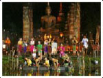 |
The festival is particularly picturesque amid the ruins of Sukhothai's Historical Park, where the event becomes a 3-day affair of parades, beauty pageants, homagepaying and folk entertainment. Loi Krathong is believed to have originated in the royal court of Sukhothai some 700 years ago.
Beneath the full moon, people from all walks of life float away onto the water small banana -leaf boats bearing a flower, lighted incense, a lighted candle and a small coin to honour, it
is believed, the water spirits, and to float away the previous year's misfortunes. |
| How To Get There |
Phitsanulok is served by regular air, rail and road services from Bangkok. The most convenient way to visit Sukhothai is by coach from Phitsanulok. |
| By Rail |
Trains leave Bangkok's Hualampong Station (Tel: 223-3762 for further details) several times daily. |
| By Air |
Thai Airways operates daily flights from Bangkok to Phitsanulok (Tel: Bangkok 628-2000 or 280-0060 for details). |
Bangkok Airways connects Bangkok directly with Sukhothai (Tel: Bangkok 229- 3434, 229-3456, 535-2429 or 535-3756 for further details). |
| By Bus |
Airconditioned coaches and non-air-conditioned buses leave Bangkok's Northern Bus Terminal on Kamphaeng Phet 2 Road throughout the day. Tel: 937-8055 or 936- 3660 for details and fares. |
| Accommodation |
A comprehensive list of airconditioned and non-airconditioned accommodation, and restaurants, in Phitsanulok and Sukhothai, can be obtained from the local Tourism Authority of Thailand office on Boromtrailokanat Road. The office is open seven days a week, throughout the year, from 8.30 AM until 4.30 PM. |
| Tak |
Tak is a northern province coverin an area of 16,406 largely mountainous square kilometres. The provincial capital is 426 kilometres north of Bangkok, and is a gateway to Myanmar to the west, and the northern Thai cities of Lampang and Chiang Mai. |
| City Attractions |
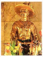
| King Taksin the Great Shrine |
Located near the Tak TAT office, this statue of Tak's most famous native son (1734-1782) is the site of an annual fair from December 28 until January 3. King Taksin was the Thai monarch who expelled the Burmese from Thailand after the 1767 destruction of Ayutthaya as the Thai capital. |
| Banphot Swamp |
This scenic, extensive area within the heart of Tak city is located near Wat Mani Banphot on Paholyothin Highway. Inside the temple, a Chiang Saen Buddha image dating from the late 1200s is enshrined. |
| Khao Tham |
Located in Tambon Mai Ngam, this 71-metre rocky hillock, near Paholyothin Highway, contains replicas of the Lord Buddha's Footprint on the summit. Tak residents pay homage throughout the year, most particularly during Songkran, which marks the traditional Thai New Year each April 13. |
| Out-of-City Attractions |
| Wat Phra Boromthat & Ancient Tak City |
This monastery, located 25 kilometres upstream, in Amphoe Ban Tak, in an area which used to be the former site of Tak city. There are several ruins in the area, including a hilltop pagoda which was constructed, according to legend, by King Ramkhamhaeng of Sukhothai (reign: 1275- 1317) to commemorate his victory in single combat on elephant back against King Khun Sam Chon, the ruler of Muang Chot (currently Amphoe Mae Sot). |
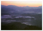
| Bhumibol Dam |
Thailand's largest dam is located some .. kilometres north of Tak city in Amphoe Sam Ngao, and dams the Mae Ping River. The extensive reservoir forms a picturesque lake that extends northwards to Chiang Mai's Amphoe Hot. Accommodation is available at the dam. Contact the Electricity Generating Authority of Thailand at (Bangkok) 436-3179 or 424-0101 for further details. |
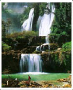
 |
Tak city, and accessed by a 3-kilometre road, the park contains the scenic Lang Sang and Pha Phung waterfalls. Accommodation is available. Contact the National Park Division of the Royal Forestry Department in Bangkok, Tel: 579-0529 or 579-4842 for further details. |
| Taksin Maharat National Park |
Originally named Krabak Yai National Park, after the name of Thailand's biggest tree, this 37,250-acre national park is located 2 kilometres off the Tak-Mae Sot Highway, some 26 kilometres from Tak city. The mountainous area has several scenic viewpoints, evergreen forest, waterfalls and streams. Accommodation, primarily in the form of bungalows and camp sites, is available. Contact the National Park Division of the Royal Forestry Department in Bangkok, Tel: 579-0529 or 579-4842 for further details. |
| Doi Musur Hilltribe Development & Welfare Centre |
Located on the road to Lan Sang Waterfall, the area is one is which Lahu, Lissu and Meo hilltribes reside. Hilltribes products are for sale at Km 29 on the Tak-Mae Sot Highway. |
| Mae Sot |
This riverside settlement on the Moei River, facing Myanmar (Burma) on the opposite bank, and some 86 kilometres from Tak city, is well known for its shopping opportunities, especially for Burmese goods such as cloth lengths, gemstones and decorative items. A recently constructed bridge spanning the Moei River permits convenient access between Thailand and Myanmar. |
| Tham Mae Usu |
This cave, boasting notably beautiful stalactites and stalagmites, is located on the scenic Mae Sot-Mae Sariang Highway (Route 1085), at Km. 95-96. It is necessary to ford the Mae Usa stream in front of the cave to gain acccess. This may not be possible during the annual Rains Season (July through October). |
| Doi Mae Ramoeng & Mon Krathing |
Doi Mae Ramoeng is some 130 kilometres north of Mae Sot on the Mae Sot-Mae Sariang Highway. Mountain scenery is particularly spectacular in the morning when mist swirls through the peaks. The area is rich in wildlife, particularly deer species and numerous types of birds. |
| Amphoe Umphang |
Amphoe Umphang is 164 kilometres south of Mae Sot on Highway 1090. The scenic highway's highest point is some 1200 metres above sea level. The winding route takes some 4 hours to complete, particularly during the Rains Season or the Cool Season when mountain mists impede progress. |
 |
Rafting, including white-water rafting, is possible on the Mae Klong River. which flows between cliffs and picturesque waterfalls and contains several scenic rapids. Birdwatching opportunities abound, and several trekking variations, by vehicle, foot, elephant-back and boat are available. Most rafting trips originate in Umphang and make for the Karen hilltribe village of Ban Pahlatha and beyond. Details of such trips may be obtained from the Tak TAT office (Tel: (055) 514-341-3). |
| Thi Lo Su Waterfall This spectacular waterfall is located in the Umphang Wildlife Sanctuary and can be visited only from November through May. Would-be visitors to the waterfall and wildlife sanctuary are recommended to enquire first with the TAT office in Tak (Tel: (055) 514-341-3) for information regarding travel conditions and camping opportunities. The waterfall can be reached by rafting and trekking by foot through surrounding forests, or on elephant-back.
How To Get There By Car The 5-6 hour road journey by car from Bangkok is made via Sing Buri, Chai Nat and Nakhon Sawan. The distance is 426 kilometres. |
 |
| By Bus |
Airconditioned coaches and non-air buses leave Bangkok's Northern Bus Terminal on Kamphaeng Phet 2 Road throughout the day. Please contact Bangkok 937-8055 or 936-3660 for further details. |
| By Air |
Thai Airways (Tel: Bangkok 628-2000 or 280-0060 for full details) operates flights from Bangkok to Mae Sot. |
| Shopping & Souvenirs |
Popular local souvenirs include mangoes and bananas preserved in honey, tamarind, and decorative granite items. Mae Sot is a good place to purchase Burmese products, including silverware, lacquerware, rubies and other gemstones. |
| Special Events |
| Loi Krathong Sai |
Loi Krathong, Thailand's lovely annual 'Festival of Lights'. on the full moon night in November, is celebrated in a unique manner in Tak. Local people thread together their krathongs which are launched simultaneously and appear as lighted necklaces on the Ping River. |
| Taksin Maharachanusorn Fair |
Celebrated annually from December 28- January 3 at the Taksin Shrine and provincial sports field, the fair features religious ceremonial and processions, displays and nightly folk entertainment. |
| Accommodation |
A comprehensive list of airconditioned and non-airconditioned accommodation, and restaurants, in Tak can be obtained from the local Tourism Authority of Thailand office on Taksin Road. The office is open seven days a week, throughout the year, from 8.30 AM until 4.30 PM. |
| Khamphaeng Phet |
The province covers an area of 8,607 square kilometres. The provincial capital is 358 kilometres north of Bangkok. Kamphaeng Phet dates back some 700 years and is a UNESCO-designated World Heritage Site. The Khamphaeng Phet Historical Park, located some 5 kilom-etres outside the provincial capital, is divided into two areas, those within the ancient city walls, and those without. |
 |
The former encompasses the Khampheang Phet National Museum, Wat Phra Kaeo with its Sri-Lankan-style pagoda, and Wat Phrathat. The latter includes Wat Chang Rop, Wat Phra Non, Wat Phra Si Ariyabot, Wat Sing and Wat Awat Yai. The Namtok Khlong Lan National Park is 65 kilometres west of Khampaeng Phet provincial capital and contains picturesque waterfalls, as does the Mae Wong National Park 79 kilometres from the provincial capital on the Klonglan-Umphang highway. |
| Phetchabun |
The province covers an area of 12,668 square kilometres. The provincial capital is 346 kilometres north of Bangkok. The province is best known for its historical sites, including the Si Thep Historical Park wherein archaelogical ruins are some 1,000 years old, and the Phu Hin Rong Kla and Nam Nao national parks which are renowned for crisp mountain scenery, rock formations, and cool weather. |
 |
Uttaradit
The province covers an area of 7,838 square kilometres. The provincial capital is some 490 kilometres north of Bangkok. The province is best known for its scenic beauty. Wat Phra Thaen Sila At, Wat Phra Yun Buddha Bhat Yukhon and a Cultural Centre at the Governor's residence are the major attractions in the provincial capital.Rural attractions include
the scenic Sirikit Dam, the world's largest teak tree in Amphoe September, the the September, the provincial capital hosts a Langsat Fair to celebrate the popular local fruit. |
| Phichit |
Phichit dates from the mid 1000's. The province covers 4,531 square kilometres. The provincial capital is 344 kilometres north of Bangkok. Phichit contains several historic temples, and is best known for its annual regatta. Boat races, processions and beauty cointests are staged on every first Saturday and Sunday of September on the Mae Nam Nan near the provincial capital's riverside Wat Tha Luang. |
| Nakhon Sawan |
The province covers an area of 9,579 square kilometres. The provincial capital is 240 kilometres north of Bangkok and marks the spot where four rivers, the Ping, Wang, Yom and Nan unite to form the Chao Phraya River that flows southwards and dissects Bangkok before flowing into the Gulf of Thailand. The provincial capital's Bung Boraphet lake is the largest aquaculture source of freshwater fish in Thailand. The lake area encompasses a museum and aquarium and a waterfowl park. Nakhon Sawan celebrates Chinese New Year with |
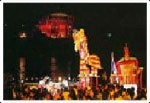 |
special elan, featuring Dragonand Lion Dance processions and musical parades, usually either during late January or early February. |